Downloads
Seleziona prodotto

Scegli

 
Aggiornamenti software Manuali utente Gpx Converter Photo DB Creator


Per mantenere il tuo navigatore aggiornato, scarica
Geosat Suite!


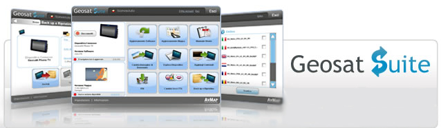
Geosat Suite è un’applicazione per PC che aiuta a mantenere il navigatore AvMap sempre aggiornato, consente di personalizzarne i contenuti e di condividerli con gli amici.

1. Scarica Geosat  Suite sul tuo PC (questa operazione è necesaria una sola volta).
2. Connetti il Geosat al PC con il cavo Usb fornito, e la Suite avviserà automaticamente ogni volta che sarà disponibile un aggiornamento per il tuo  navigatore.
3. Scarica l'aggiornamento per il navigatore gratuitamente. Connetti il tuo Geosat  al PC periodicamente per tenerlo aggiornato!

  
Avviso importante: Geosat Suite è temporaneamente non disponibile, si prega di contattare [email protected] per assistenza.
 

Cosa otterrai tramite Geosat Suite

Tramite la Geosat Suite potrai aggiornare il software del tuo navigatore all'ultima versione:
 

Aggiornamento Software 2.01.86R - 14-12-2006

ATTENZIONE!!!  QUESTO AGGIORNAMENTO RENDE INUTILIZZABILE LA MACCHINA SE NON SI E' IN POSSESSO DI CARTOGRAFIE T-AS-N730.xx, T-EA-N740.xx, T-AM-N750.xx, T-CU-N777.xx O SUPERIORI.

 
  1. New format and new coverage for all the cartographies. Land elevations and road net available worldwide
 
  1. New updated detailed terrestrial coverage (EKP IV PRO version only).
 
  1. The runway numbers displayed always on the pictorial for the airport independently from which info source (quick info or database info page).
 
  1. In the HSI when the XTE is greater than the full scale indication, the deviation bar of the ruler changed with a ‘>’ or ‘<’ sign to display an “out of scale” condition. Applied also to the CDI data field.
 
  1. Course Up mode with Terrains (TAWS) is now aligned to Track Up behavior
 
  1. Map rotation on TRACK UP mode made continuously in accord with the HEAD UP RESPONSE setting also when in any TERRAIN mode.
 
  1. If there is no Course defined, then COURSE UP mode NOT ALLOWED; if already in COURSE UP mode with a destination, and DEACTIVATING it, then mode switch to NORTH UP mode.
 
 
  1. The info regarding the Jeppesen cycle (the cycle number, the validity period Start Date and Expiring Date) displayed on Title page and on About page
 
-
  1. The indication of the current de-clutter CYCLE is displayed on the data window scale and north indicator field.
 
  1. In any display condition, when pressing for more than 3” the CYCLE Key the result is:
a)              Abort the current menu operation if any.
b)              Return to the Moving Map Page.
c)              Exit, eventually, the Cursor Mode and enter the moving fix (if the fix is currently available) mode (normal navigation mode).
 
  1. .Saving/restoring MORE than 1 set of checklists (one pilot flies more than one aircraft) to XML-file is now available
 
  1. It is now possible to save and load the CHECKLISTS data to/from the CF XML-file and to DOWNLOAD/UPLOAD it from/to the EKP.
 
 
  1. It is possible to save all changes in Active FP from FP Page menu and the location for saving changes in Active FP may be chosen by the user from the FP list.
 
  1. Numbers of the Flight Plans increased to 15.
 
 
  1. Added a functionality of sending out GGA and RMC sentences with minimal delay since they are received form GPS.
 
  1. Added handling of Sirf III GPS.
 
  1. Added Sirf III WAAS operation.
 
  1. Added handling of UbloX GPS. (up to 4Hz refresh rate)
 
  1. Added UbloX WAAS operation.
 
  1. WAAS satellite symbol and SNR bar drawn in blue color on GPS page.
 
  1. Numbers of satellite channels on GPS Page increased up to 15
 
  1. Range Rings, when ON, displayed in COURSE UP mode as well.
 
  1. Drawing circle around fix with radius selected by user via main menu “System Setup”->”Fix Setup”->”Fix Circle Range”.
 
  1. Selective searching for the nearest airports (for small, large and all airports) available. Setup in “GENERAL SETUP” -> “NEAREST AIRPORTS” menu.
 
  1. Menu item GOTO-> Select Approach available for FP containing an airport as destination point.
 
  1. Added Turn Rate Indication to data fields selection and to the NAV/LOCATION Page.
 
  1. The Vertical Speed and Turn Rate data fields displayed on the total navigation page (HOLD PAGE in map mode).
 
  1. Vertical Speed Indication added to the data field selection and to the NAV/LOCATION Page
   
  1. Changed format of “Offset Dist” parameter on VERTICAL NAVIGATION Page (added one decimal position).
 
  1. If the arrival “ETA’ will be from Sun Rise to Sun Set no special symbols will be displayed; if it will be from SS+60min to SR-60min (the official Night time) a red ‘N’ letter will be displayed. If the arrival will be from SS +30 to SS+60min a red ‘T’ letter (Twilight) will be displayed; if it will be from SR-60min to SR a yellow ‘T’ letter (Twilight) will be displayed. If the arrival will be from SS to SS+30min (VFR day Landing allowed, but no Takeoff) a yellow ‘D’ letter will be displayed.
 
  1. The vertical Navigation Descent point is computed for the LAST point in the FP, or the Destination point if in Direct to Mode.
 
  1. The VSI (Absolute Value) maintained with the maximum precision, but displayed   rounded to the nearest 100 ft/min or 0.5 m/sec.
 
  1. Complete restructure of the Flight Plan management with “HOLD” at a waypoint, added capability.
 
  1. For the PRO added the capability to communicate up to 38400 baud.
 
  1. Added new language – Spanish to EKPIV interface
 
Versioni precedenti Versioni precedenti Problemi? Visita le nostre FAQs Problemi? Visita le nostre FAQs
<<  < page 12  13  14  15  16  17  18  19  20 of 26 >  >>
Assistenza

GARANZIA

I Navigatori AvMap sono garantiti 2 anni dalla data di acquisto.


Hai bisogno di Assistenza per
il tuo navigatore AvMap?


1.   Registra il tuo Navigatore

2.   Leggi la Sezione FAQ Domande Frequenti

3.   Se non trovi la risposta che cercavi, scrivici compilando la richiesta di assistenza oppure chiama il nostro Call Center allo 0585 784044

4.   Il Servizio di Assistenza risponderà prontamente.  Se necessario, ti verrà inviato un codice di riparazione ‘RMA’ con le istruzioni per spedire il navigatore in riparazione.

5.   Potrai controllare in ogni momento lo stato della tua riparazione.