
The alternative charts
|
|
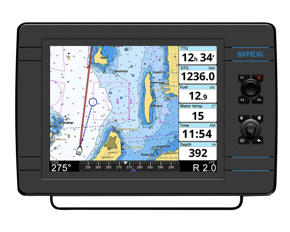
The essential charts for boatersUS vector charts for marine navigational systems
POLARIS charts are used on chart plotters on many types of ships and by recreational boaters, providing real-time ship positioning. POLARIS charts are based on the Official NOAA ENC® charts.
|
polaris format
 |
FORMATOne essential format |
polaris charts coverage
 |
COVERAGE
|
Polaris charts updates
 |
UPDATESOne essential update |
Polaris charts features
What's in POLARIS charts?
All the essential features
|
Hydrographic Organization ENC vector Charts |
|
Port plans |
|
Select safety depth |
|
2D view |
|
Dynamic tides and currents |
|
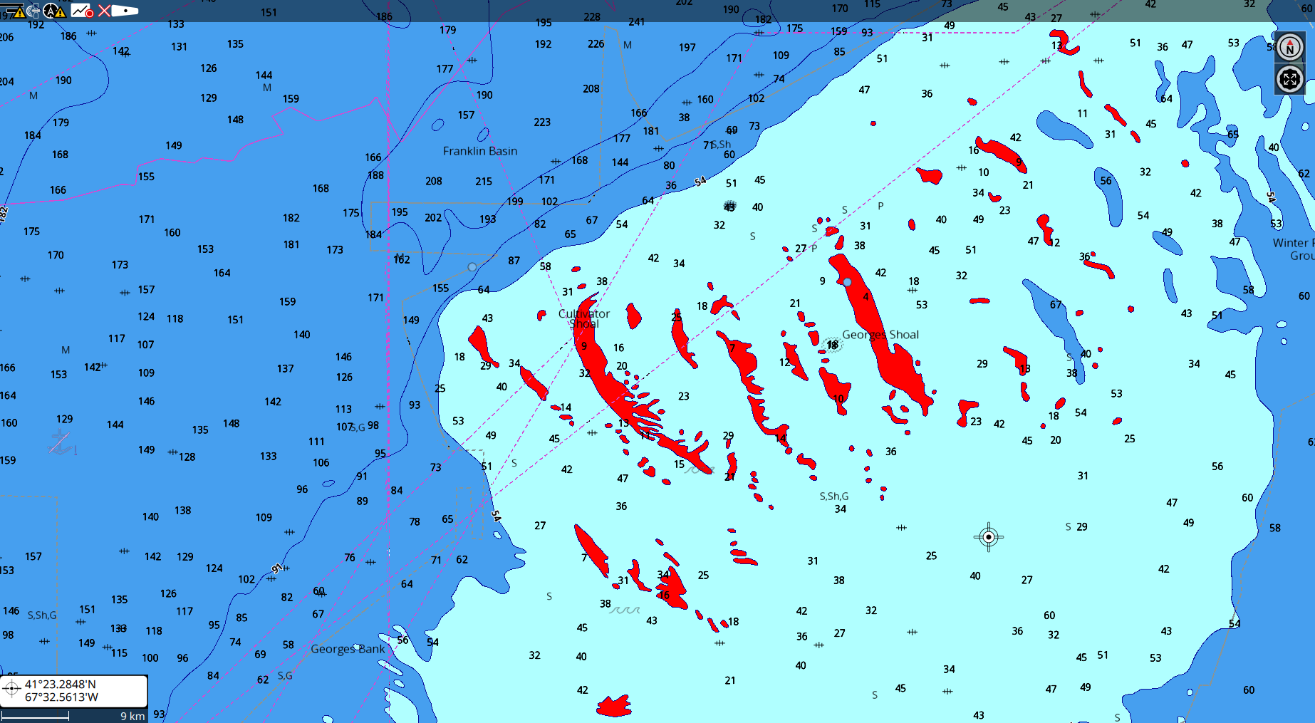
High resolution bathymetry |
High resolution Bathymetry
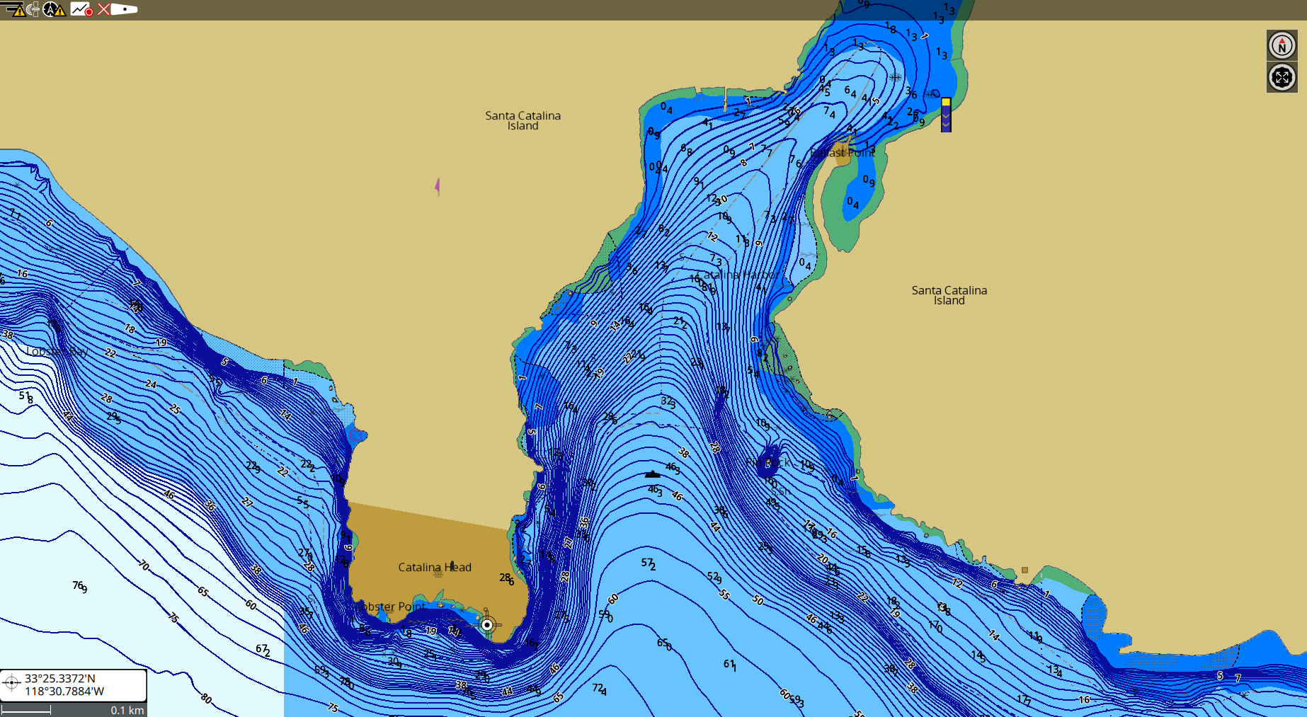 |
High Resolution BathymetryPOLARIS Charts |
Dynamic Tides
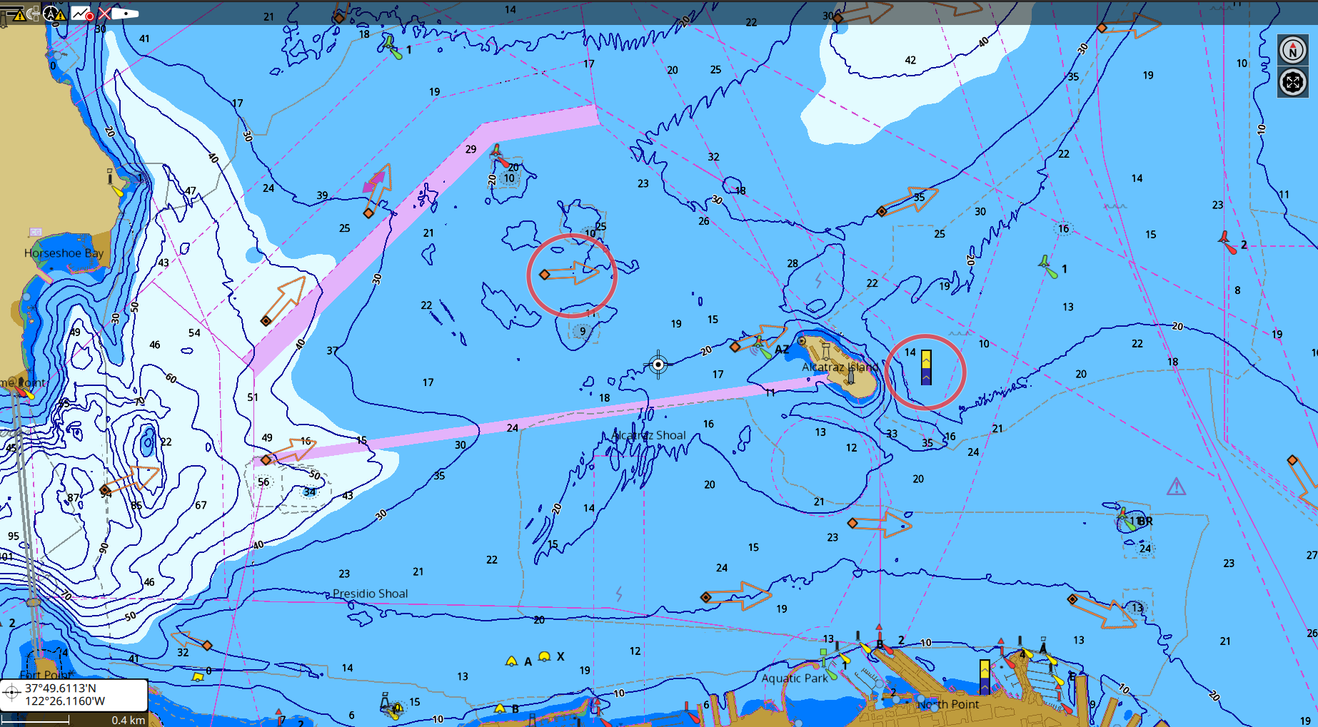 |
Dynamic TidesPOLARIS Charts |
Ports plan
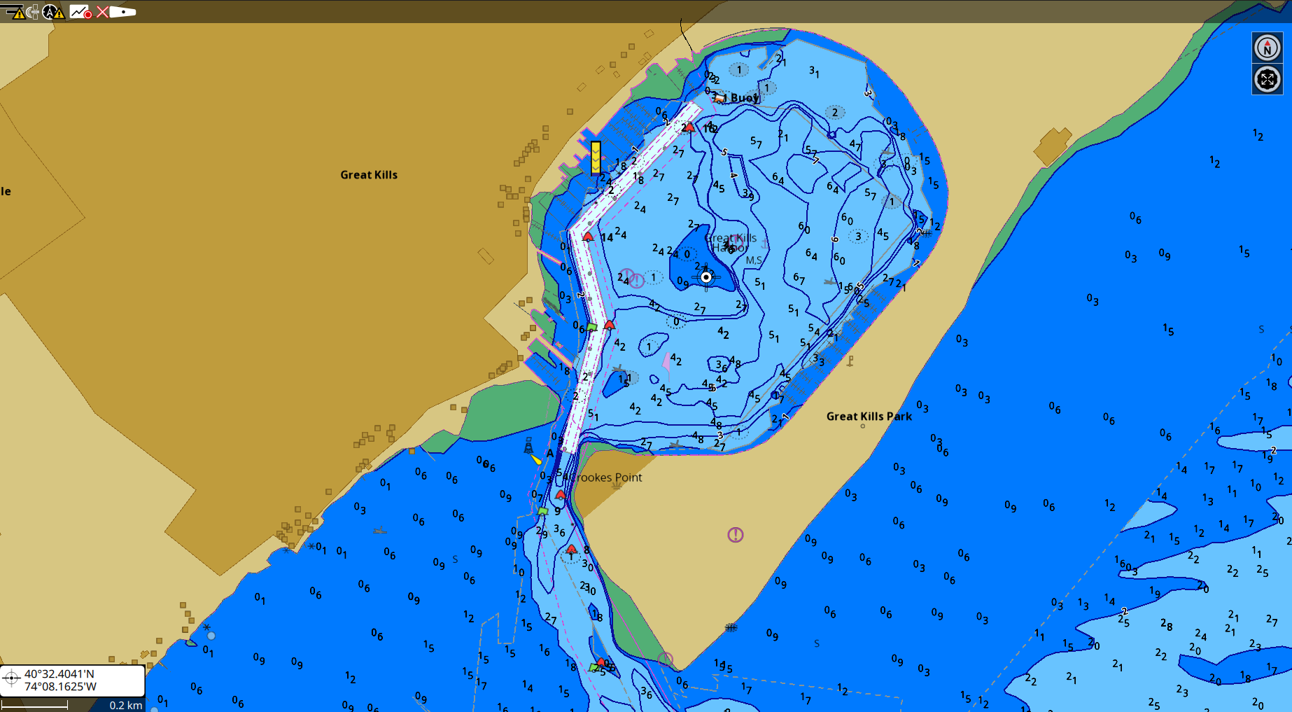 |
Port plansPOLARIS Charts |
Safety depths
 |
Safety depthPOLARIS Charts |
Polaris Charts Easy to use and to update
How do POLARIS chart work?
Easy to use and to update
Compatible products
Where can I find POLARIS charts?
Brought you by SI-TEX
Available in the North American market directly from SI-TEX.
EXPLORER Nav PRO
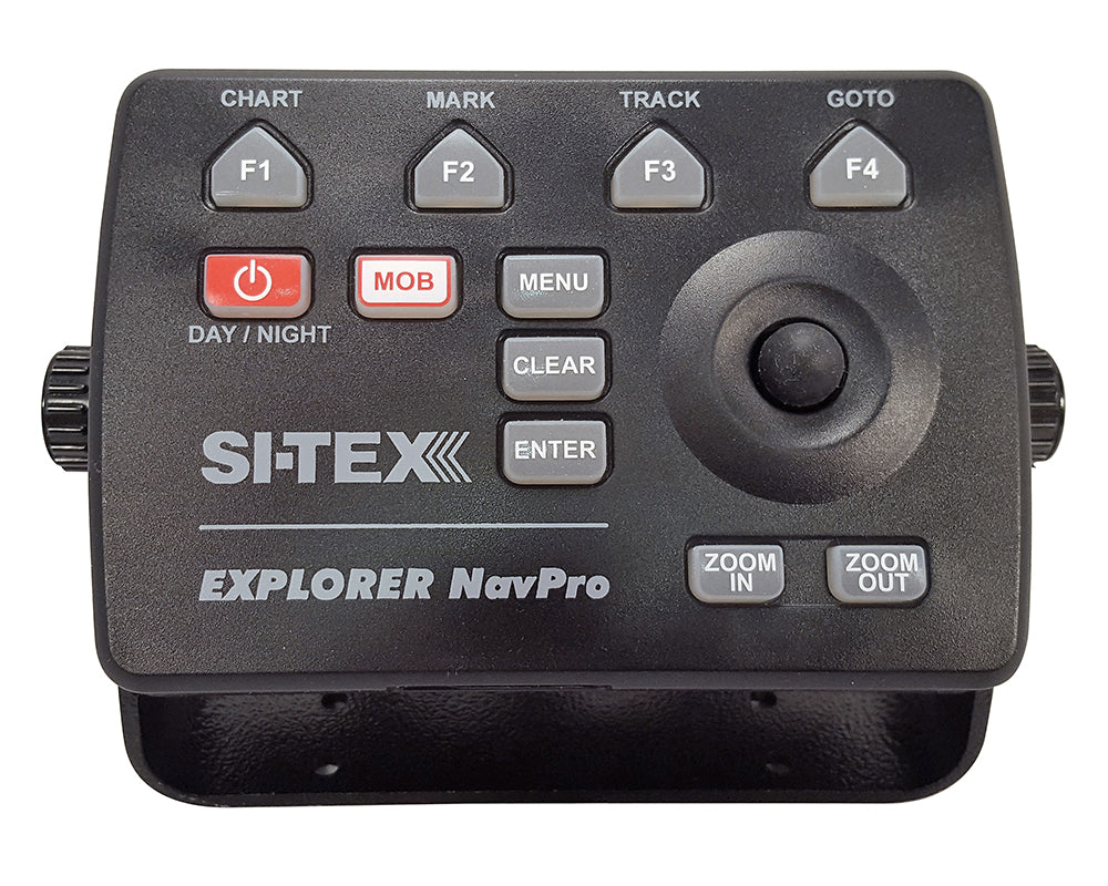 |
|
SI-TEX |
NavPro 900
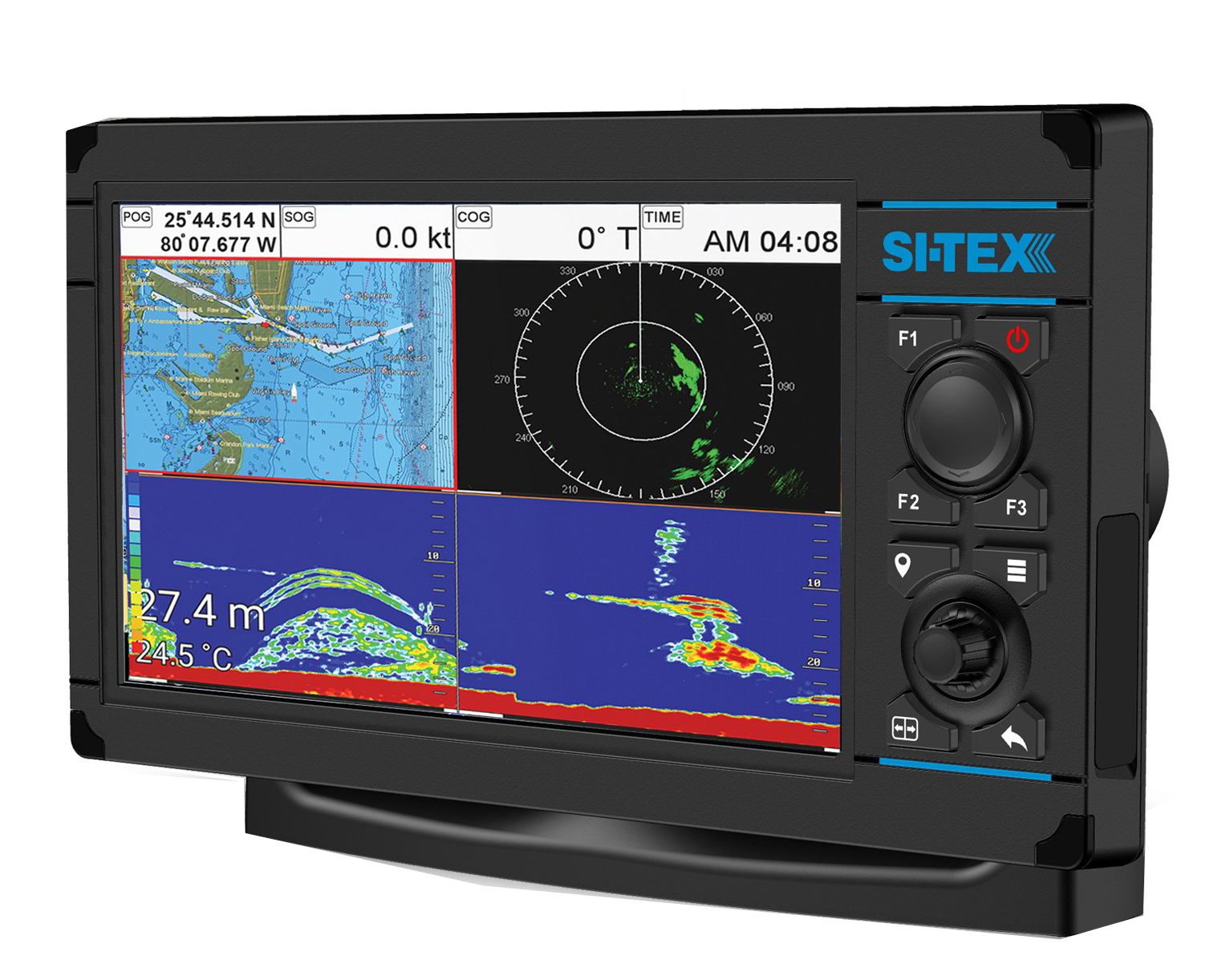 |
|
SI-TEX |
Nav Pro 1200
 |
|
SI-TEX |
About us - POLARIS charts
|
|
POLARIS CHARTS END-USER LICENSE AGREEMENT
POLARIS charts
END-USER LICENSE AGREEMENT
PLEASE READ CAREFULLY THIS LICENSE AGREEMENT (“AGREEMENT”) BEFORE USING POLARIS CHARTS. THIS AGREEMENT IS LEGALLY BINDING UPON YOU (“YOU”) AND AVMAP SRL A SOCIO UNICO (AvMap).
THIS IS A NON-EXCLUSIVE LEGAL AGREEMENT BETWEEN YOU AND AVMAP: BY USING THIS POLARIS CHARTS INTO YOUR PRODUCT, YOU AGREE TO BE BOUND TO THE TERMS OF THIS AGREEMENT. IF YOU NOT AGREE WITH THESE TERMS, YOU CANNOT USE THE POLARIS CHARTS.
As a party to this agreement, you agree to the following terms and conditions:
1. DEFINITIONS
Product: means AvMap Polaris Charts, any and all coverage, purchased through an official distributor or reseller or through the website, in digital format and/or loaded on specific media (e.g. memory cards).
Device: means any hardware device compatible with AvMap Polaris Charts and used to display the AvMap Polaris Charts.
Data: the cartographic data contained in the Product, derived from NOAA ENC®.
2. OWNERSHIP AND COPYRIGHT
All rights, title and interests, all trademarks, service marks, design rights, proprietary information rights and other intellectual property rights in the Product are reserved by AvMap and/or its affiliates and third-party licensors.
The Product is based on NOAA ENC® data source. All rights in Data are reserved by the NOAA®. By accepting the provisions hereunder, you also accept the terms of NOAA ENC® that you can find at: https://www.charts.noaa.gov/ENCs/ENC_Agreement.shtml
The Product includes a worldwide background map with ©OpenStreetMap data for the Canadian coast line for the Great Lakes which can be downloaded here. All rights in OpenStreetMap data are reserved by ©OpenStreetMap. By accepting the provisions hereunder, you also accept the terms of ©OpenStreetMap that you can find at: https://www.openstreetmap.org/copyright
To the maximum extent permitted by applicable law, such protected works may not be copied, reproduced, translated, modified, adapted, reversed-engineered, decompiled, stored in a retrieval system, or retransmitted in whole or in part, in any form or by any means.
This Agreement does not grant you any rights in connection with any trademarks or service marks of AvMap. All rights not expressly granted are reserved by AvMap and/or its affiliates and licensors.
3. LICENSE
The Product is licensed to you, not sold to you, for a single usage in a navigation system. Subject to the terms and conditions herein, AvMap grants to you the non-transferable, personal, non-exclusive right to use the Product, only for usage in a navigation system in the scope of a navigational aid. The Product shall not be considered in anyway a replacement for official government charts.
4. PERMITTED USES
The Product can be only used on your Device as a supplement to official navigation information, not as the sole or primary method of navigation.
The Product shall be considered as an aid to navigation, not replacing any official navigation chart and traditional navigation techniques.
You agree to use reasonable efforts to protect the Product from unauthorized use, reproduction, distribution or publication.
5. RESTRICTIONS ON USE
The Product and other things provided hereunder are for private use only and not for commercial use.
6. PROHIBITED USES
You may NOT (i) copy, duplicate, reproduce or publish the Product; (ii) distribute, sell, or otherwise transfer copies of the Product; (iii) change, in whole or in part, modify, adapt, translate, reverse engineer, disassemble or decompile the Product; (iv) create derivative works based on the Product; (v) delete or obscure any AvMap or other third-party copyright or trademark notices.
Any unauthorized reproduction, use, or transfer of the Product may be subject to legal actions from AvMap.
7. WARNINGS
Nautical navigation is a dangerous activity and should only be engaged in by persons with adequate training and experience.
The Product shall be exclusively used as a navigation aid. Only official government charts and notices to mariners contain all information needed for a safety navigation and the captain is the sole responsible for their proper use and awareness of current conditions.
The Product is subject to periodical updates that will render the Data obsolete and inaccurate. The Product may not contain all nautical navigation data existing worldwide and you should make no assumption otherwise.
AVMAP MAY UNDER NO CIRCUMSTANCES BE HELD LIABLE FOR DEFECTS DUE TO INCORRECT OR MISSING INFORMATION IN THE PRODUCT.
8. DISCLAIMER
TO THE MAXIMUM EXTENT PERMITTED BY APPLICABLE LAW, THE PRODUCT IS PROVIDED “AS IS” WITHOUT WARRANTY OF ANY KIND. AVMAP DISCLAIMS ANY AND ALL OTHER WARRANTIES, WHETHER EXPRESS OR IMPLIED, INCLUDING, WITHOUT LIMITATION, ANY IMPLIED WARRANTIES OF ACCURACY, COMPLETENESS, OPERABILITY, MERCHANTABILITY, FITNESS FOR A PARTICULAR PURPOSE OR NON-INFRINGEMENT. YOU ASSUME THE ENTIRE RISK AS TO THE PERFORMANCE AND RESULTS OF PRODUCT.
YOU ACKNOWLEDGE THAT THE PRODUCT IS OF A GENERAL NATURE, AND THAT IT MAY NOT BE DESIGNED FOR, ADEQUATE TO, OR CONFORM TO YOUR SPECIFIC NEEDS AND/OR PURPOSES, NOR THAT IT CONFORMS WITH SPECIFIC SAFETY REQUIREMENTS OR GOVERNMENTAL STANDARDS OR REGULATIONS IN YOUR COUNTRY.
SOME JURISDICTIONS DO NOT ALLOW THE LIMITATION OR EXCLUSION OF LIABILITY FOR INCIDENTAL OR CONSEQUENTIAL DAMAGES, SO THE FOREGOING LIMITATION OR EXCLUSION MAY NOT APPLY TO YOU.
9. LIMITATION OF LIABILITY
TO THE MAXIMUM EXTENT PERMITTED BY APPLICABLE LAW, IN NO EVENT SHALL AVMAP AND/OR ITS AFFILIATED AND LICENSORS BE LIABLE FOR ANY INDIRECT, INCIDENTAL, CONSEQUENTIAL, SPECIAL, OR EXEMPLARY DAMAGES OR LOST PROFITS, ALSO IN CASE AVMAP HAS BEEN ADVISED OF THE POSSIBILITY OF SUCH DAMAGES.
IN ANY CASE, AVMAP’S ENTIRE LIABILITY FOR ANY LOSS OR DAMAGES RESULTING FROM ANY CLAIMS, DEMANDS, OR ACTIONS ARISING OUT UNDER ANY PROVISION OF THIS AGREEMENT SHALL NOT EXCEED THE PURCHASE PRICE YOU PAID FOR THE LICENSE TO USE THE PRODUCT.
10. INDEMNIFICATION
To the maximum extent permitted by applicable law, you will indemnify and hold harmless AvMap and its affiliated and licensors from and against all claims and liabilities, costs and expenses, damages to any property, loss of profit, incident thereto or incident to successfully establishing the right to indemnification, for injury to or death of any person or arising out of your use of the Product provided hereunder, whether or not arising in tort or occasioned by the negligence of AvMap. Your obligations under this indemnity will survive the termination of this Agreement.
11. EXPORT COMPLIANCE
You shall be the sole responsible for compliance with any applicable export control restrictions, laws and regulations imposed by the governments. You shall not attempt to export the Product covered under this Agreement to any country to the extent prohibited under any applicable laws. You shall, at your sole cost and expense, obtain and maintain in effect all permits, licenses and other consents necessary hereunder.
12. DURATION AND TERMINATION
This agreement is effective from the day you start using the Product. The license to use the Product granted under this Agreement will automatically terminate without prior notice from AvMap if you fail to comply with any of the use restrictions or prohibited uses provisions of this Agreement or if you fail to comply with any mandatory law applicable to your use of the Product. Additionally, AvMap may terminate this Agreement immediately and without prior notice to you if you breach any term or condition of this Agreement. In such event, you will not be entitled to reimbursement of any amount paid to AvMap.
Upon such termination, you shall destroy or delete the Product in your possession.
13. GOVERNING LAW AND JURISDICTION
This Agreement shall be governed by the laws of the Italy, without regard to its conflicts of laws provisions. To the maximum extent permitted by applicable law, any dispute, controversy or claim arising out of or relating to this Agreement shall be submitted to the jurisdiction of the Court of Massa, Italy.
14. REVISIONS
AvMap reserves the right to change or modify any of the terms and conditions of this Agreement at any time without notice. Any changes or modifications to the terms and conditions will be effective 60 days after the date the change or modification is made. We invite you to sometimes revise these Terms on our website. If you do not accept the new terms, you must immediately terminate the use of the Product.
15. GENERAL PROVISIONS
Failure or neglect by either party to enforce at any time any of the provisions of this Agreement shall not be construed or deemed to be a waiver of that party's rights under this Agreement. If any provision of this Agreement is held to be void, invalid or unenforceable, the remaining provisions shall not be affected and shall remain valid and enforceable.